Dam project improves safety
Published 9:22 pm Friday, May 29, 2015

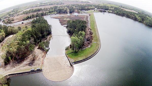
Seen from the air is a spillway being recapped under the City of Norfolk’s Western Branch Reservoir Project. The spillway work is one of five project elements. (Submitted Photo)
In the woods off Godwin Boulevard just south of Reid’s Ferry Bridge, the city of Norfolk is in the middle of a major engineering project to bring its Western Branch Reservoir up to federal standards for dam safety.
The $30 million project is required after the reservoir was assessed under federal regulations as a high-hazard dam whose failure would probably result in lost lives, according to Harry Kenyon, management services administrator with the Norfolk Department of Public Utilities.
“In addition, there would be economic and environmental losses,” Kenyon added.
The reservoir holds about 6.4 billion gallons of water. It’s “a principal source of water for Norfolk, Virginia Beach, Chesapeake and area military installations,” Kenyon added.
Why now for the upgrades? The assessment was under recent changes in federal regulations to improve dam safety across the country, according to Kenyon.
“For years, Norfolk has maintained a comprehensive program of reservoir management and dam safety to ensure we are in compliance with federal regulations,” he added.
Mel Hopkins, a civil engineer with the city of Norfolk, explained the scope of the project during a tour on Friday. It essentially involves five elements, he said.
In Hopkins’ opinion, the “key element” is construction of an emergency spillway, enabling the reservoir to withstand a “probable maximum flood.” “It’s a flood that’s beyond the 500-year flood,” he said.
The spillway is about 500 feet wide – as opposed to about 150 feet for the primary spillway – and would safely spill water down Western Branch when flooding exceeds a once-in-a-century event, according to Hopkins.
By necessity, it will also be the first element completed, he said — by the end of this year.
The next element is a 3,000-foot-long cutoff wall, reaching from the emergency spillway back to near Western Branch Pump Station.
Reducing seepage from the reservoir, the wall will run as deep as 90 feet, Hopkins said. It’s being built with a massive machine that looks something like an amusement park’s freefall tower, which simultaneously drills six holes three feet in diameter.
Onsite batch plants are making the concrete/clay mix that’s poured into the holes. It mixes with the soil then hardens, Hopkins said.
“It looks like concrete, but it’s a lot better than concrete,” he said.
Next, the primary spillway is being recapped. They’ll take what resembles a giant saw, Hopkins said, and take about two feet off the concrete structure, before recapping it with fresh concrete.
Closer to Route 10, engineers are raising the east side concrete parapet by two feet, and as part of that, another element involves building up the earth embankment beneath it by 8 to 10 feet.
To do that more effectively, Hopkins said, they’re installing 2,000 wick drains, which, as the name suggests, wick water to drain it from the earth.
“So the ground will consolidate quicker, because we are in a high water table area,” Hopkins said of the thinking behind the wick drains.
“It’s not a nightmare, but it’s a little problematic for the contractor.”
The wick drains are driven 35 feet into the ground, according to Hopkins, and it takes only about 30 seconds to install one.
Kenyon said the Western Branch Reservoir project is due for completion in April 2017, and it’s Norfolk’s last dam project in Suffolk related to the recent changes to the federal regulations.
A project at Burnt Mills Reservoir, which was also assessed as high-hazard, was completed a couple of years ago, he said.
The current project is being financed through a 30-year capital improvement bond, according to Kenyon.
“This project will enhance our ability to manage the reservoir and prevent downstream flooding during historically high rainfall events,” he added.
The city of Norfolk also had to develop an “emergency action plan” to be implemented if something goes wrong with the reservoir, Hopkins said.
“For engineers, this is a dream-come-true project,” he said.


